
Vision Through Digital Communications
Learning Objectives
Emerging GPS, Way Finding and Crowd-Sourcing technologies are changing our lives, and giving independence and confidence to persons with vision loss. We are crossing a new frontier in the evolution of computing and entering the era of cognitive systems. scientists and engineers around the world are pushing
the boundaries of science and technology to create machines that sense, learn, reason, and interact with people in new ways to provide insight and advice. Read on to learn how BlindSquare and iBeacon services can expand your world with new possibilities. Explore the new frontier through digital communications, and enjoy the freedom of travel as a participant in an increasingly mobile society.
Know where you are, know where you're going!
travel with confidence!
Learn About
GPS And Way Finding
What Is GPS?
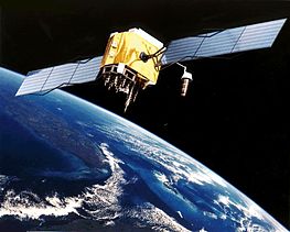
The Global Positioning System (GPS) is a satellite-based locating and navigating utility that determines a user's precise latitude, longitude and altitude by tracking signals from satellites. The GPS is a satellite-based navigation system, that was put in place by the U.S. Department of Defense. The GPS constellation of satellites was declared operational in late 1995 and consists of 24 satellites orbiting Earth to provide worldwide coverage, 24 hours a day, free of charge. GPS satellites send two signals: a carrier and a pseudo-random code. The signals are timed by an atomic clock in the satellite, and the GPS receiver generates a matching code timed by its own synchronized clock. The time it takes for the signals to reach the receiver indicates how far away the satellite is. This calculation is generally performed using the pseudo-random code signal, but for better precision, the carrier signal can be used instead. To make position calculations, GPS receivers use signals from four or more GPS satellites. The first three satellites are used to triangulate a position. The fourth is used to improve the position's accuracy by factoring in the time offset between the satellite system's clock and the GPS receiver's clock.
Our ability to use GPS so far is limited by the relatively poor connection to the satellite feeds when we are indoors in buildings, homes, or behind anything that could obstruct the GPS connection. However with the investment and development in a new satellite network called Galileo which should be completed in the near future, these problems should be eliminated drastically. Like the Internet, GPS is an essential element of the global information infrastructure. The free, open, and dependable nature of GPS has led to the development of hundreds of applications affecting every aspect of modern life.
Who Uses GPS?
These days doctors, scientists, farmers, soldiers, pilots, hikers, delivery drivers, sailors, fishermen, dispatchers, athletes, and people from many other
walks of life are using GPS systems in ways that make their work more productive, safer, and easier. Your imagination is the only limitation to the possibilities of global positioning system (GPS) technologies. GPS systems are extremely versatile and can be found in almost any industry sector; on land, at sea and in the air. Basically, GPS is usable everywhere except where it's impossible to receive the signal, such as inside most buildings, in caves and other subterranean locations, and underwater.
Global positioning system applications generally fall into 5 major categories:
How Is BlindSquare Changing Lives?
The blend of new digital signals and the tools to process them create new opportunities for us to rethink the way we approach traditional problems. GeoIntelligent programs can create a new framework for collecting data and shape accessibility strategies in a way that increase confidence and independence. The parallel for the blind community is obvious, and the Blindsquare app is transforming lives through location intelligence. BlindSquare takes advantage of the rapidly growing GeoSpacing data analysis system services, and is pioneering accessible GPS navigation on iOS devices using a haptic interface with a dynamic range of user interactions. It all started in May 2012 in Helsinki Finland with The blind leading the seeing, no problem!
GPS Resources
Introduction To BlindSquare
BlindSquare is the World's Most Popular accessible GPS application developed for the blind and visually impaired. It describes the environment, announces points of interest, and street intersections as you travel. In conjunction with free, third-party navigation apps it is a powerful solution providing most of the information blind and visually impaired people need to travel independently.
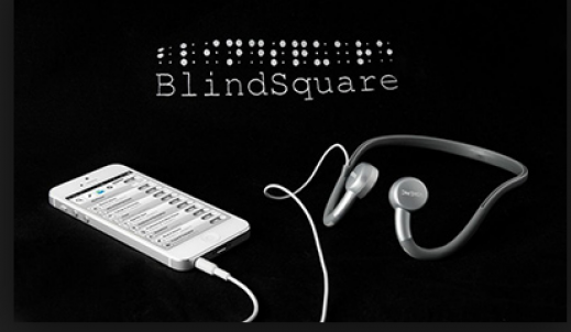
The BlindSquare app is a digital solution that combines the latest technology to help the blind with their daily lives. It has been developed in collaboration with blind people and carefully field tested. BlindSquare, an accessible GPS app, is capable of describing the immediate environment and announcing location information, and is currently used in more than 150 countries, by more than 20,000 people, in about 25 different languages. BlindSquare integrates social media services like FourSquare data with Apple's native VoiceOver technology to create a location-based virtual map through sound. Users can enhance the application with recommended accessories; such as braille displays and the Aftershokz bone conduction head set, which leaves users' ears open to natural sounds. When the app is enabled, it reads addresses, street names and surrounding locations aloud, and directions are available on demand. Note, the BlindSq Event app, a free iOS app in Apple store, is a fully functioning BlindSquare service, but only works at the venue time and location of special events, and when you select the demo mode the app will simulate a location for you. It will behave as if you were at the simulated location and you will be able to try many of its features.
The BlindSquare was conceptualized and created in 2012 by Finland-based Ilkka Pirttimaa, and he calls it a mashup of GPS technology; speech synthesis, crowd sourced data through FourSquare and augmented reality with audio.
BlindSquare
BlindSquare Resources
Learning To Use BlindSquare
Session 1: Getting Started
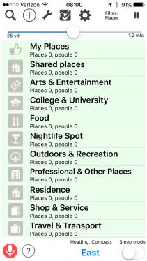
When you start the BlindSquare app, it will start by telling you your current location and some interesting places and street names around you. You may hear two voices speaking at the same time; the iOS VoiceOver and the BlindSquare voice for automatic announcements. The main screen of BlindSquare is divided into three sections. At the top you will find seven buttons. From left to right they are Search, Add Place, Tools, Foursquare, Other, Filter Announcements, and Mute Speech. Below these buttons you will find the radius slider. The largest part of the screen is taken up by a list of search categories, where different interests can be searched. Along the bottom of the screen are four Buttons, left to right; Voice Commands, BlindSquare Help, Heading/Accuracy/Speed, and Sleep Mode. Just above these Buttons is the Local Info Button.
Refer to the BlindSquare User Guide for more information.
Session 2: Setting User Preferences
Session 3: Outdoor GPS Navigation
As more blind people travel for business and leisure, the use of GPS among the blind community will increase. Typically, navigation with automatic positioning is normally used as a client-based application. This means that the position is determined directly on the smartphone of the user and thus requires an app. Navigation software uses maps to pinpoint a person in the context of surrounding geographical references. Unfortunately maps are not always accurate. Changes frequently occur to structures, streets, curbs, and objects on the ground. Where no mailbox was on the corner yesterday, one appears today. This type of information is not updated in the public map database. Thus a GPS system cannot guarantee safety for a blind traveler; only good mobility training and independent traveling skill can. However, no doubt anyone with good basic travel skills can benefit from the advancement of GPS technology. GPS accuracy and Geographical Information Systems, are adapted to vehicle navigation, and fail in assisting pedestrian navigation, especially for the Blind. Navigon and TomTom both offer mobile apps, that perform similarly to their standalone portable units and are accessible, but are not blindness aware.
After generations of upgrades, mobile phones today have an increasing variety of sensors, such as accelerometers, gyroscopes, electronic compasses, barometers, etc; Which BlindSquare takes advantage of, so as to provide as much information as possible. GPS coordinates, latitude and longitude, provide a position location, but are not user-friendly and are easy to mix up. That is, GPS coordinates are hard for people to remember, and do not necessarily describe a building's entrance. Imprecise street addresses can be challenging to describe, find, and navigate to; A street address might be defined as the centre of a building rather than an actual entrance. Some buildings have multiple entrances, and places like coffee shops, stores and venues often share names. What3Words claims to have sectioned the planet into sections three meters square, and to have given each section a three-word designator. This facilitates navigation to places where addressing might not be very precise. To solve this issue as well as the difficulty in communicating location, BlindSquare has integrated the new What3Words grid system into the app. People can search for or input three word addresses and get directions to an exact three meter by three meter square they need to make their way to. They can also ask the app to announce their current three word address that they can then easily share with anyone they like.
Learn more about the "What3Words" location system, or
Find out how BlindSquare uses What3Words in this YouTube video.
Organizations can take advantage of the BlindSquare power by integrating the MIPsoft navigational information services into their enterprise infrastructure. The Customized Location Information Service (CLS), developed by MIPsoft, allows organizations to provide customized information about their premises to blind and low vision guests. Clients, students, or staff who use an iOS-device running BlindSquare or BlindSq Event can have immediate navigational information about the organization premises. Through a simple online interface, organizations can enter GPS coordinates of points of interest and descriptions of these points. BlindSquare can retrieve this information as soon as it is entered, or updated, and will read it out to the BlindSquare user. The CLIS can provide detailed information about a street intersection, and information about the surrounding environment.
Iowa State University, Discovering Campus Through a Different Lens employs CLS to notify blind students of entrances of buildings, steps, or temporary construction work, when they approach an entrance or an obstacle. If a familiar route is blocked due to road works, it is possible to suggest an alternative route to the user.
BlindSquare users can create their own digital bread crumb trails, and share it with other BlindSquare users, across university and college campuses, across a large mall parking lot, through a transit service centre, and around a sailing club dock facility. Users can create and share landmarks for objects like mailboxes, art sculptures, benches, doorways, stairways, and much more. These are only some examples where BlindSquare is being used.
Session 4: Indoor Beacon Navigation
If your business is people-oriented, sooner or later it will have to adapt in order to be where your customers are: in their smartphones! One of the innovative technologies that connect your business with people is the Bluetooth beacon. A beacon is a small, electronic device that broadcasts low energy bluetooth radio signals That can be received by any smart device which is in range and equipped with Bluetooth. Beacons are equipped with a coin size battery, and the smart device does not need to pair with beacons to be able to receive the radio signal. The Beacon simply transmits its ID, and the application running on the smart phone uses this ID to display the appropriate data to the user. Note, Beacons themselves do not use the Internet, as they only transmit their unique ID using wireless Bluetooth Smart technology, to The receiving device; So it is your smartphone, not the Beacon that will need Internet connectivity. Beacons are inexpensive, easy to use, install, and maintain. Sharing information related to a specific place or object is one of the most popular and simple Beacon functionalities. You can use beacons to share useful information about your product or service with people passing by; Such as, send an agenda, an event notice, or a restaurant menu directly to customers nearby. Beacons can improve customer experience by sending a welcome greeting message as people enter the venue. Way finding technology is being installed permanently worldwide in malls, museums, airports, and subways.
Learn more about Beacon use cases, or
Watch the Youtube Beacon proximity explained.
Navigating inside of public buildings (Stations, malls, office buildings) poses different challenges to blind and partially sighted people than travelling in the streets. Outside, visually impaired people often find more landmarks (pavement, tactile paving, different echoes of walls, trees, bushes, fences, audible traffic lights) than are available inside of buildings. Inside office buildings, doors and corridors are similar. In shopping malls, paths are often blocked by signs or decoration, constant background music masks echoes, and other audible clues are lacking. Printed signs are inaccessible to blind individuals. GPS reception generally is too poor to compensate these difficulties using smartphones.
Quick Response Codes (QRC) can provide a great deal more information for a specific location. Such as restaurant menus, physical layout of washrooms and other public spaces, and office and mall directories.
Session 5: Connecting With Mainstream Apps
BlindSquare uses a wealth of data to inform you about your environment. BlindSquare uses the Open Street Map service to find information about streets, paths, highways, intersections etc. Open Street Map is a free map of the world created and updated by its users. It works similarly to Wikipedia in that contributors use GPS-devices to record geo-coordinates and upload the resulting data to Open Street Map. BlindSquare queries FourSquare for Points Of Interest data of venues, like museums, restaurants, schools, libraries, etc. FourSquare is a location based social network. Its users can check in to venues using their smartphones or computers to report their current location to their Foursquare friends. Note, some FourSquare users add irrelevant places to FourSquare, so to ensure BlindSquare announcements are actually useful, BlindSquare will filter these places and only announce venues where at least five different users have checked in.
BlindSquare can be used in conjunction with several third-party apps. Some of them offer spoken turn-by-turn directions. Others can help you to use public transport, order a taxi, or find additional Points Of Interest. BlindSquare can run in the background so it can be used together with other GPS apps like TomTom, Navigon, and Apple Maps. This lets you use these apps to hear turn-by-turn instructions and BlindSquare's description of your environment at the same time. BlindSquare, using Foursquare and Open Street Map data, announces public and private Points Of Interest (POI), as well as street intersections, if the user is within a defined radius of these points. The BlindSquare app makes use of Foursquare's two billion check in points worldwide, to help blind pedestrians find locations on foot or while using public transportation. The 20 million+ people on Foursquare have created an incredibly detailed crowd sourced directory. The FourSquare framework allows third parties to add information on top of check in data. For example, if you check in at a restaurant, a diet related app might suggest appropriate meals, while a social app could tell you if any of your friends have eaten there, and if they left any comments.
BlindSquare supports several public transportation apps. If one of them is installed on your device, you can look up schedules and services at your current location to a destination. To look up a connection to your destination, search for your destination, open its Place Summary screen, and find the Public Transport button. Double-tapping it will open a menu where you can select one of the supported public transportation apps installed on your device. When you select one of them, BlindSquare will send the coordinates of your current location and the coordinates of your destination to the app of your choice. The app will open and you can continue looking up the desired information from within the selected app.
The Transit App lets you view public transport services at your current location and plan trips to other destinations. For example,
Uber is a taxi service available in several countries and cities. If you register with Uber, you can order a taxi and also pay for your ride using the Uber app. If it is installed on your device, BlindSquare will display an Uber button on each Place Summary screen. If Uber is available in your area, the button will also show the cheapest available ride to the selected Place. Double-tapping the button will open a menu where you can select one of the available options. Double-tap one of them to select it. This will send information about your current location and your destination to the Uber app and open it. Now you can continue in Uber and order your taxi.
Learn how to use the Transit App from within BlindSquare - AudioBoom, or
Learn how BlindSquare and Uber make traveling as easy as a breeze - AudioBoom.
Session 6: BlindSquare Enterprise Infrastructure Integration
Youtube Video BlindSquare Lessons
Take Action with BlindSquare
Are you a BlindSquare user, or a Certified Orientation and Mobility Specialist (COMS), wanting to learn more about the power of digital navigation? Then contact me for more information!
Are you a member of an organization wanting to give your blind customers or employees the power of independent navigation freedom? Then contact me for more information!
Let's start an open dialog on building digital pathways to the future!